always
set your browser window to full screen (f11)
The Guided Tour
This will give you a flavour of what is contained in this history
When you go around yourself you can pick any starting point, but it helps to have some ideas of what you want to read and see. The history is a “ramble and see what you can on the way”. You can take any route you like. Before taking a hypertext link, place the cursor over the link to see the tip on what to expect. Remember that you can always return by clicking BACK on the browser toolbar above. Have you hit F11 yet, it will make it much easier to see what you are doing?
If you first take a look at the prehistory Prehistoric Yarmouth, you will learn something of the ancient origins.
If you want to learn about Yarmouth’s setting in the scheme of national historical writing, read the treatise on Local History in England. You will find all these items to be very detailed.
However, instead of a simple list of suggested items, this guided tour will now be an extract of a few of the thousands of historical items that you can browse.
To start with the treatise on local history writing here are three extracts that put Great Yarmouth’s history in context:
The Development of Local History Writing.
Historical writing may appear to be a more or less
continuous developmental process that is reflected in the nature of works by
historians. In reality the process is much more complex. To some extent the
period that they worked in determined the style of the work. Irrespective of
the personality, the approach to the subject demonstrates some adherence to a
national pattern. Certain major figures appear responsible for stimulating
changes in style, but are not responsible by themselves for their introduction,
which is a collective process that happens across the centuries in an
inconsistent manner. Some counties and
regions miss out at times in terms of history. The earliest historians could
only pass on small numbers of copied manuscripts, and so the scope for peer
influence was limited. With the advent of printing however, there was ready
access to the work of others, and a current style of historical text was able
to develop. Caxton found historical
texts to be a ready source for his printing press, and provided readily
saleable material for commercial use (laws of copyright were not established
until 1709).[1] Caxton thus disseminated the works of the
earliest writers, and the process of development of historical writing was
greatly boosted. Nevertheless, many early historians were more antiquarian
collectors of documents and information than true historical writers, and this
only changed with the initiative of William Dugdale who established a style of
writing and presentation that prevailed until the twentieth century. How his work influenced others working
subsequently on their histories of various towns and counties will be examined
in some detail in the main chapters of this dissertation.
Then another extract-
The style of individual narratives generally does adhere to precedent and tries to establish a contemporary norm. Bale should perhaps be credited with the introduction of a new style of writing that persisted through the works of such as Gibbon, who was one of very few to make a financial success of historical authorship. Bale has not been liked, since he rewrote Hollinshed, but the style he popularised, lasted two centuries. The collective approach and presentation of Camden and Dugdale similarly had a lasting influence that in Yarmouth was copied by Henry Swinden. Elsewhere Francis Drake of York followed a similar model with his History and Antiquities of York in 1836 Drake introduced many plates and maps, but this might well have been Swinden’s intention in Yarmouth also, if he had not died before publication. Blomefield used a questionnaire to enable the collection of data from places that he would otherwise have found impossible to visit. The practice of circulating such questionnaires was however widespread, and not the innovation of Blomefield.
And a third-
The Historians and Histories of Great Yarmouth
The previous page(s) were an extract from this dissertation,
now given in full.
Contents:
Introduction
The development of local history
Background history of the town of Great Yarmouth.
Chapter 1
Damet’s writing and Rutledge’s work confirmed.
The influences upon Damet and his successor, Henry Manship,
and the resultant state of their writing (From Caxton and Leland, to Hollinshed
and Speed).
Chapter 2
Blomefield’s history: how it relates to Yarmouth and its
origins and place in the general historical scene. Le Neve and his influence
and relation to Yarmouth History.
Chapter 3
Henry Swinden, his work of 1730-70, the style of the age,
and how it developed, following Camden, Dugdale, Le Neve. Swinden as a
contemporary of Parkin and Blomefield.
Chapter 4
Maps, some lost and rediscovered. The tales which they tell,
and how different authors have used them and been influenced by them.
Chapter 5
Charles Palmer, his life and works, and how they were
produced. Others elsewhere who may have
influenced the results. How his writing fits into the pattern of general and
regional historiography.
The Histories and Historians of Great Yarmouth.
Introduction.
This dissertation will follow the
development of historical writing in Great Yarmouth from the time of Damet’s work
in the 1570's until the death of Charles Palmer in 1888.
Clearly if you wish to read more you should go to that work. This may have been sufficient to give you a flavour. Now we will look at some extracts of “Prehistoric Yarmouth, and then some extracts from some streets and rows, where the main part of this history resides. In all cases there are hyperlinks to these items from the “Front page”, and if you want to read the full text you must use that route. After a while you will simply get to find your way about best by just nosing around and trying different items on different occasions.
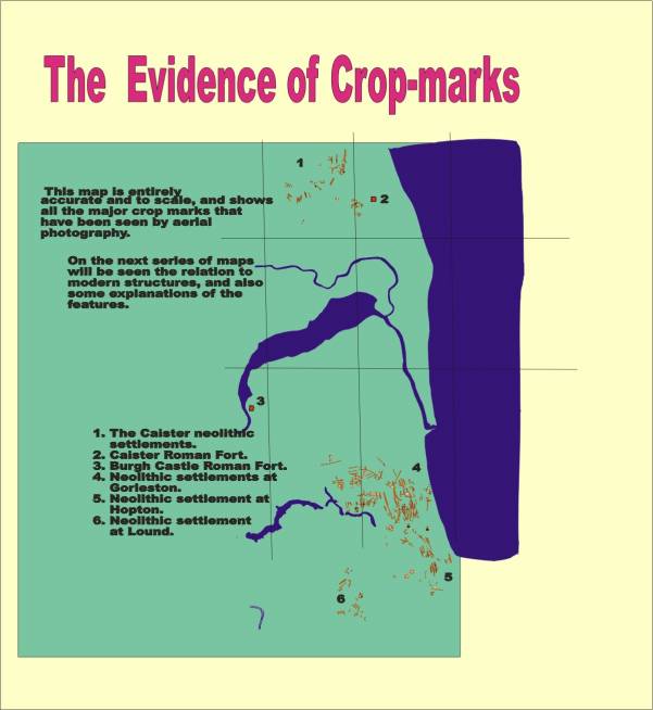
Pre-Historic
Burials
In the stone age landscape, perhaps 5-8,000 years ago,
there was an intensely settled, and well marked out landscape of small
settlements and established and defined trackways. Burials took place in or
beside circular barrows, and possibly some of the circles noted in the aerial
photos and marked on the scale plan, were henge sites, where religious
ceremonies and burials, perhaps sacrifices may have taken place. Cinerary urns,
an early and a fourth century Roman coin, were found at Runham Vauxhall in
brick earth in 1879, apparently below sea level. This could not be explained,
since it was thought that the sea level had been higher, whereas the digging of
the broads shows the area not to have been constantly under water. ( peat_digging.) This nevertheless, is one of several
instances of Roman artifacts in an area that was said not to have existed
before a thousand years ago.
Prehistoric
Roadways
The trackways are very clear in places, and it appears
likely that the subsequent Roman roads,
and the modern roads from Yarmouth
to Lowestoft, Yarmouth to Haddiscoe, and Yarmouth to Caister, are extremely
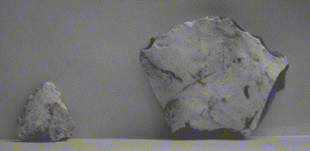
ancient routes. A very fine stone axe was found beside Long Lane at Corton, and
I wonder whether Long Lane, which apparently leads nowhere, since it does not
lead directly to Corton, is the remnant of a roadway to Newton, where it
perhaps led in common with Station Road Hopton, and Stirrups lane, Corton.
Although this may be is more in the realms of imagination, nevertheless, since
the north sea was once dry with absolute certainty following the ice age, right
across to the continent, the coast was as far away as one might imagine,
dependant only upon the date.
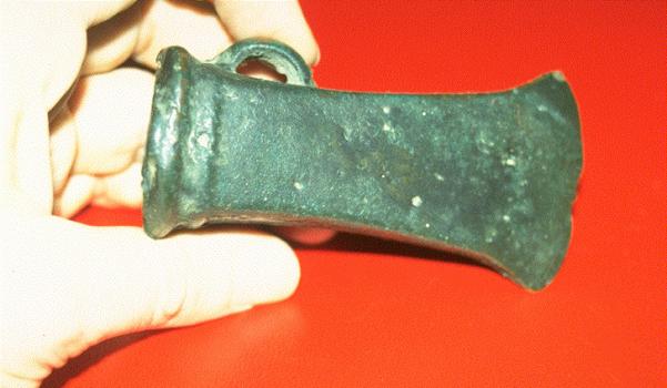
Stone age axe head found at Peterhouse School playing
field.
A Roman
Villa at Browston?
There clearly was a track that led from the north-east
to Browston Hall. This seems have led either to a stone age circle and settlement, or possibly the site of a Roman Villa. It has been
suggested that the crop marks might alternatively represent a formal garden for
the Elizabethan Hall there, although there appears evidence of a much more
extensive settlement. This and the existence of primitive trackways leading to
it from the north-east, points to something much older.
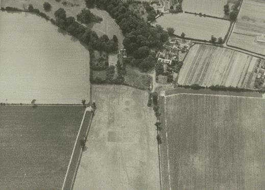
Aerial photo of Browston, 1976. © Norfolk Museums and
Archaeology Service, photo by Derek Edwards.
A Roman
Villa at Cantley
There are similar crop-marks on high ground at
Cantley, that are thought by Derek Edwards*12a
to represent a Roman Villa site, although once again, there has been no
archaeological investigation.
Bronze
Age Settlement
At Gorleston
there have been three finds from the bronze age, that point to a Bronze Age
village. The first discovery of Bronze-Age axe heads was made at the north-west
corner of the Magdalen playing field. It may well be that excavation of that
field, as yet unbuilt upon, could reveal further evidence of Stone Age and
Bronze Age settlement.
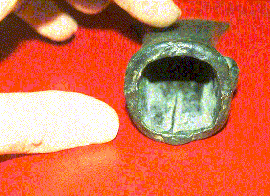
A find of several axe heads was made in 1952 in a
trench cut to lay a pipe. This has been called "Gorleston hoard I".
Another hoard was discovered some years
prior to 1966,
and has been called
"Gorleston hoard II". The latter was exchanged with, and can be seen
at, the Birmingham museum. The find was on the site of the Magdalen Arms public
house. It was privately discovered and kept secret at the time. "Gorleston
Hoard I", can be seen on display at the Tolhouse museum. There are a
considerable number of socketed axe-heads, parts of sword blades, and some
scrap bronze. It is thought to represent
the secret store of a bronze merchant or smith. It would have been very
valuable. One further find of a bronze axe head, in May 1991, was made by
Andrews and Squires builders, when Dr.Kumar's surgery in Stuart Close was
extended towards the pavement. The axe head was lying only some nine inches or
more below the surface, and beside the public footpath.
Yet another discovery of Bronze age axes is recorded
to have been made, at the old Rectory at Somerleyton,
in 1926.*12 Somerleyton may be of further interest in
the future. On 12th.Sept.1994, I identified an area in a field about 500 yards
south-west of the church, which has many small fragments of brick and some
small pottery sherds.
Flint scrapers from Hopton, near White House Farm.
(found by myself)
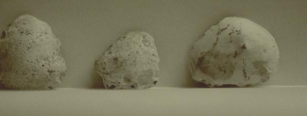
Small scrapers from field South of the 13th
hole at Gorleston Golf Course. (found by me)
The modern village is nowhere near the church, and so
this may well be the site of the medieval village. There are other possible
reasons for the incidence of such fragments, and a careful survey is needed,
before jumping to conclusions. At the same spot I also identified an earlier
relic, a large flint scraper of the semi-circular variety.
Flint axes from Corton Long Lane, photo by
P.E.Rumbelow. (now at Norwich castle museum)
A hundred yards further south in the wood, is a most
unusual earthwork, that appears to be a claypit, but which has some curiously
shaped mounds at the north-east corner, that may also be well worthy of further
investigation.
Neolithic
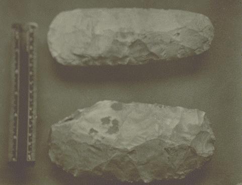
flint tools
There are finds of Stone Age tools that have been made
all over the area between Yarmouth and Lowestoft. Mr.Bullock at Hopton picked
up some remarkable examples of worked flints over a thirty year period to 1951,
and some of the best of these were photographed by Rumbelow.
these flint tools from Hopton photographed by
P.E.Rumbelow
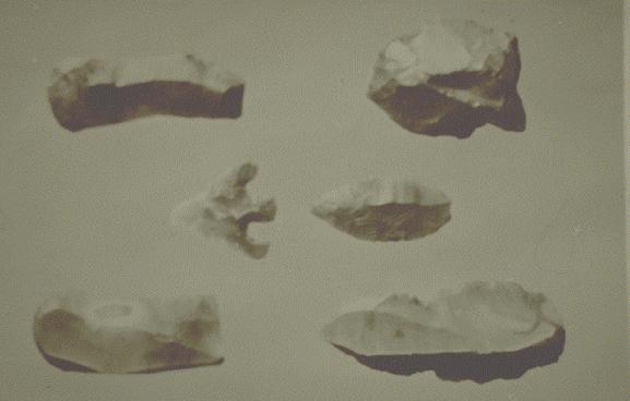
Iron Age
hut sites
There is a saucer-like depression east of the A12
road, immediately south of Links Road at Gorleston, which is in a field that
exhibits an enormous number of crop markings, and easily produces stone tools.
This depression appears to represent
the remains of a stockade.*13 This type of circular stockade is reported as being used to
contain the valuable livestock, dwellings
being built around the outside. Another pair of such saucer-like
depressions can be found about 500 yards south of Lound Church, on top of a
small rise. Both these sites appear worthy of skilled investigation. Strangely,
they are both double depressions, so perhaps human habitation was within one,
with animals occupying the other. A significant number of ring-ditches can be
seen on the aerial photos. These would have been a fortification around an
individual hut. At least one of these is within the bounds of what seems to
represent a large ploughed-out bank. Such a bank may well be part of a larger
fortified site or "hillfort". (see "Prehistoric
Settlements" by Robert Bewley, 1994, p.110.)
This is the depression East of the A12, referred to
above.
And opposite Lound Church.
Further similar saucer-like man made settlements are
to be found beside Butt lane, opposite the Roman fort; to the north-west of the
Green Lane/ Beccles Road junction; at least four at Somerleyton, with
especially good examples beside the "Glebe House"; and S.W. of the
Haddiscoe to Hales road; also at Raveningham.
A great
river 500,000 years ago
It was suggested to me by Andrew Rogerson that these
ideas were nullified by the finding of an ancient and huge river running from the
midlands, south-east of Birmingham and winding through Leicester, across East
Anglia and through Hoxne towards the North Sea. - Professor D.Coope, David Keen, et al*14 have reported a river bed at Waverley Wood Farm, where there
was an occupation leaving stone tools, at least 500,000 years ago. This surely
represents the surface of the clay layer pre-glaciation, that overlies the chalk, and becomes
overlain by deep sand to the east of Hoxne. The sand was undisturbed from the
glacial deposition when excavated this year at Scole. This river, I suggest,
ran into the chalk valley (covered by clay) that I have described above. We can surmise that there was a great river
at Yarmouth some 500,000 years ago, no doubt with its banks occupied by ancient
man, but in no way does this river relate to the Yare or Waveney, which are
post-glacial features, or to the inter-glacial period, although there possibly
was a river here then also.
Medieval
Yarmouth
It appears that there was an enormous fire in the
south part of the town before the Norman Conquest, whereas it is recorded that
the Priory of the Blackfriars was destroyed by fire much later in the Middle
Ages. It now seems clear that there was an enormous fire at least in the whole
of the area from South Quay to King Street in the line of Rows 128 and 129 in
about the year 1000. It appears so great that it spared nothing. The evidence
for this is an entirely continuous layer about 2 feet thick, 3.5-4 metres below
present ground level, which is in its entirety full of black charcoal and
burned fibre of straw and reed. This is such a substantial layer that it cannot
possibly represent any small or isolated fires of any cause, such as a firing
of a large area of marram grass. The layer contains fish bones in most places.
Due to the commercial nature of the excavation very little material was
examined, and only a very few pottery sherds have been recovered. The burned
fibres remain intact and unbroken in the ground, despite being burned entirely
to carbon. This shows that the ground here was never subsequently worked
(ploughed or dug in any way). A layer of sand immediately overlays this
remarkable feature, so that the layer is entirely discrete, sharply delineated
everywhere by the clean sand layers above and below. It had appeared from the
1886 ship discovery*15, that this
layer was at the very least, 10 feet above the post glacial surface, but this
is not so, as it was not touched by the 1996 pipe trench and the 19th century
brick built sewer (and presumably the "Viking" ship) are both
cut into the glacial sand deposit. The "Viking" ship (reported
in Rumbelow’s Diary) may well be a ship burial; it has never been examined.
After the extract of prehistory, we will look at a couple of
maps
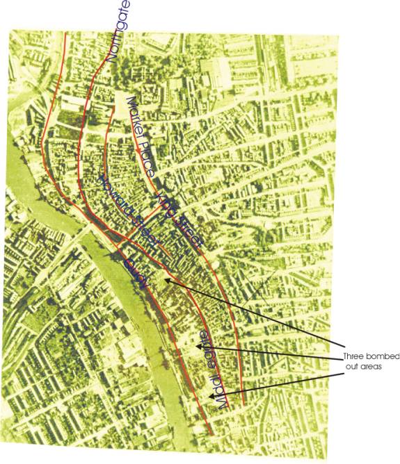
Firstly the 1946 aerial view that gives a good overview of the
town layout, and so clearly shows the differences in the town, as being
medieval until that point and something much less so after-
On the right of the river, (East) there are just three relatively small areas of total destruction and clearance. Note the roofless church at the top centre, and the Conge clearance of 1935/6, that is seen in the top left of the photo, just below and right of the old railway bridge. Take the chance to see the layout of the town here. The North- South street pattern can be easily made out, with the three main streets. In the South half of the town, there is South Quay along the river, and Middlegate and King Street to the right of the Quay. Regent Street divides the centre, and North of that is the curve of George Street leading into Northgate Street, and then Howard Street and the Market Place, whilst North Quay is alongside the river. The medieval town survived the war, and the subsequent failure to conserve is especially despicable though typical of the time. Below are the streets marked over the photo. The photo is made paler for clarity of the text.
The Elizabethan map shows the medieval town also-
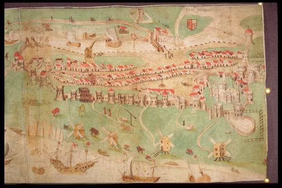
Here is the entire Elizabethan town, enclosed within its walls. There are four windmills on the Denes, the crane on the quay, a ducking stool by the bridge, and the market cross in the market place. When you examine the article entitled walls and towers, there are details enlarged from this map to show the towers.
Another way to get around is by using the “Combined Subject
Index”
This is a set of hypertext links, here are a few from the index-
Pleasure beach For the active links you must go to frontpage and then combined subject index
Now we look at extracts from two streets, and two rows-
1. an extract from “Hall Quay”
In 1938 at no. 1 Hall Quay (where today is
Havenbridge House Harry Hyam, built by ), was the building that became Steward
and Patteson's off licence and wine stores. Formerly this was the private
residence of Mrs. Munday. Taken before
the turn of the century there are some splendid photographs of her and
this beautifully sited residence, one that compares well with that fine site
just west of the north-west tower during the same period.
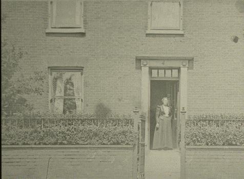
Mrs Munday at her front door, about 1890. This became
Steward and Patteson’s as seen below.
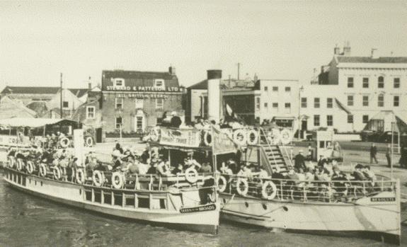
About 1950. Summer business was brisk then.
Next to the empty
offices mentioned above is the fine Georgian house that once belonged to Sir
Edmund Lacon. This became the Hall Quay Cub, then Falstaff’s Restaurant; now
Quay Leisure.
With regard to the
Hall Quay Club, the west end of the building is but two stories high, having a
Georgian doorway. The main part of the house looks to all intents as though it
has three stories, with three tiers of windows. In fact the upper windows that
appear to represent a second floor merely reflect the great height of the first
floor rooms, and the third storey does not exist. For many years there has been
a club at these premises. When the Conservative Club were here, Ernest Bullent
was steward, and resided on the premises with his wife Ethel.
Ernest Bullent, born
9/4/1900, started work here in 1914, whereas Ethel, his wife, did not start at the
club until 1936. She describes the club as having the centre upstairs room as a
billiard room. Here a man named Mason was employed as a billiard marker for 50
years. He wore a bowler hat at work. There was a boy allocated to each room,
with the bells ringing downstairs from each. They wore black trousers and
shoes, and black jackets with a fine stripe pattern, together with white
shirts. After 11 am., they were dressed in steward's pointed jackets. There was
a man who frequented the club in a straw hat and never took it off. The daily
newspapers were available, but could not be removed from the reading room.
Bridge was generally played in the small card room on the west end of the first
floor, although cards were also played in the "Big card room" with the
bow window.
Latterly of course
this room has been used as a restaurant. Large supper parties were catered for
at times, and on the occasion of the club's 50th. jubilee, there were six
courses for 70 people, including 18 pheasants. Under the house are 2 large
cellars, and a separate cellar in the back yard for coal. If there was the
combination of wet weather and a high tide, then the cellars could flood with 2
feet of water, although now there is an electric pump. The two main cellars run
parallel and the length of the house. The ceilings in the cellars are of brick and arched, a little low, permitting
standing in the centre. In the pantry was a wooden sink for washing glasses.
The floor was flagstone. During the war the Bullent's children, Gwen and Geoffrey
were evacuated, and Ethel managed the club herself. One well-known chairman of
the club was John Clymer, who was renowned as a gourmet and a first class
golfer at County and National level. He made some changes in the club,
including painting over the wooden wall side stair rails. John Clymer died in
October 2000 at the age of 81. He had served on the Lothingland Council before
joining the Gt. Yarmouth Borough Council in 1974. He was Mayor in 1979-80, and
Conservative leader. He was a director of the building firm E. Moore and Son.
He was president of the local St John’s Ambulance, and a member of the port
authority, and President of the Gorleston and Yarmouth Lifeboat. He was married to Jean who died earlier, and
left three children and eleven grandchildren.
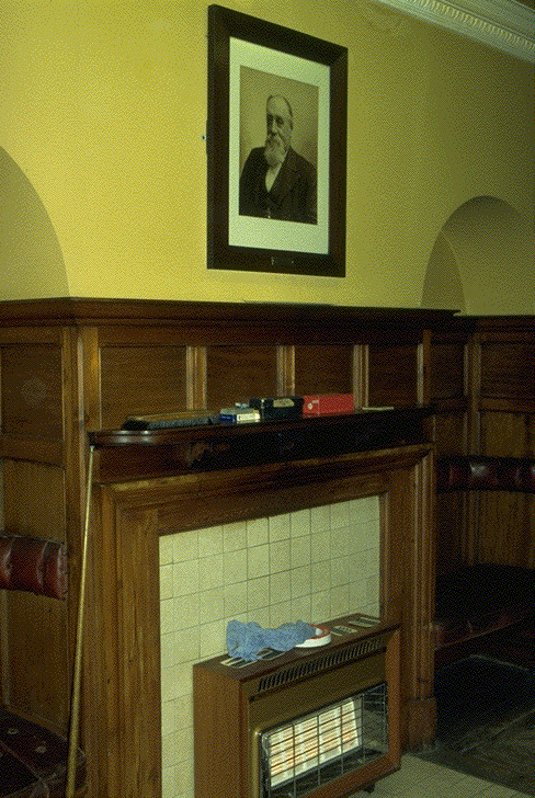
The downstairs lounge of
the Hall Quay Club was refurbished by courtesy of Tom Maltby the millionaire,
and subsequently known as "Uncle Tom's Cabin". Maltby’s picture hangs
above the fireplace shown here.
Although at the time
of writing this note (23/1/94), the Hall Quay Club was still here, the
Falstaff's restaurant had closed down due to poor trading, and the club,
suffering a loss of rent, decided to sell the premises and to cease its
functions. It has been for many years frequented by some of the prominent men
of the town, and its recent Chairmen were-
1980 D. A. Bullock
1981 M. G. Clarke
1982 W. P. Molineux
1983 N. J. Holroyd
1984 Ronald Toone
1985 M. Mussino
1986 J. Cheeseman
1987 A. G. Tayler
1988 R. W. Fackman
1989 J. R. Hannant
1990- 91 R. N. Jones
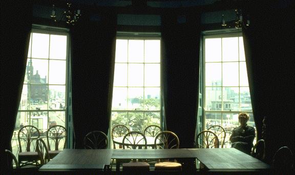
The eastern rooms of
the house have a most splendid bow front, with three fine Georgian sash windows
facing down the quay. The view from the first floor here is the most excellent
in Yarmouth. (pictured above from inside)
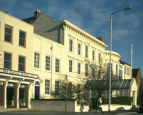
On this site was the
town house of Sir John Fastolf, K.G. Born at Caister in 1378, Sir John was
descended of Alexander Fastolf, one of the Bailiffs in the time of Edward I.
Mainly remembered as a military commander in the 15th. Century wars in France (Agincourt,
Crecy), he built a castle at Caister, and a chapel at the Abbey of St.Benet at
Hulme. He is said to have been a violent and vitriolic man, and the model of
Shakespeare's Falstaff. He died at the age of 79, his will being dated 14th.
June 1459. His will was disputed on the basis of his poor mental health. He
was thought incapable on 3rd. November.
The money from his will had been given to endow a college at Caister, and
instead it went to an establishment attached to Magdalen College Oxford. He was
a benefactor of Magdalen during his lifetime. This was the beginning of
Yarmouth's long connection with Oxford it appears. There were also bequests for
repair of the harbour and town walls.*3
now an extract from South Quay to demonstrate sound clips
During the war
some of the young lads at Bunn's warehouse, on the
opposite side of the river, kept watch up on their roof. After some passage of
war, the staff being very busy with animal feed, they tired of abandoning work
for the incessant sirens, that frequently went off, yet nothing followed.
Rather than rely on the sirens, even though there were two types of siren, one
to warn of activity in the area, and a whooping type of call that indicated
aircraft actually over the town itself, they devised their own system, taken
when this local warning sounded. Three
or four boys were rostered by Mr. Bunn to take turns and climb up a ladder to
the roof, and another short ladder up the chimney stack, and observe to warn if
the aircraft was actually headed in their direction or not. Arthur Postle or
one of the other youngsters, would be sat on top of the roof with an electric
bell-push to sound the alarm if there was any real danger, when everyone in the
office would dive for cover.
..\SOUND\Postle9Bunns
alarm system.wav
The boy would simply be hanging onto the
chimney-pot! One grey and misty day, early in 1941, Arthur was despatched to
take watch when the crash alarm sounded. There was the sound of an aircraft,
and looking in all directions through the drizzle, he could see nothing. He turned to look north, when out of the
cloud appeared a Heinkel 111, coming over the Haven bridge, at a level below
the town hall clock, and since the aircraft had now passed, Arthur did not push
the bell-switch, but the plane released five silver
bombs, which fell horizontally into the river without exploding. The five bombs
fell in the region of the cranes, and
have never been reported or found. It looked as though the plane was aiming
them at the cranes, but hit nothing.
..\SOUND\Postle8bombs
in river.wav
Digging under
fire!
It was at about
this time that the corporation decided to construct another road at the back of
Southtown. Until then there was only the one road to Gorleston,
and Suffolk Road was constructed then as an alternative route. Fortunately too,
since shortly thereafter Southtown Road was made impassable by bomb damage. The
dig for victory campaign was initiated, and the allotments created in Cobholm and everywhere that there
was spare ground that could be dug up. Young Postle was digging at the
allotment one morning, when a DO-17, having attacked Jewson's premises, where a
ship was unloading timber dropping a bomb missing it, but damaging the
quayside, and killing two dockers. The pilot could see no other activity bar
the sight of Postle digging, and so made a raid on the allotment, strafing it
with machine gun fire.
An
extract from “Row 125”
Darn
the Baker was at no.10. This is the bakery in the photograph with the sign
saying "C.Allman". Darn was known as the "midnight baker",
starting at 4 in the afternoon!, and going on until 10pm. Dick Westgate's mother was born in the
bakery. Darn had previously had a bakery shop at Rainbow corner. At one time,
prior to Darn a man called Boast had this bakery, and used to burn a lot of
paper in the oven, obtained from Wolseley and Wolseley when they had their
premises in Middlegate Street. Darn would bake your dinner in his oven for a
penny or tuppence, whereas in Allman's day it had been a fee of a
farthing. The bread, buns, men on a
stick, would be delivered by barrow through the rows.
Christopher
Allman was Rosa Westgate's father, nicknamed "Cutty" Allman. Allman
had a white beard, and was a friend of Arthur Patterson. After retiring from
the bakery, he lived with his other daughter at no.13. At some time after Darn had taken over,
William Allen (who married Doris Wilmot, ex row 108) had a job here selling
rolls hot from the oven. He had no boots then and was sent to the Town hall
with a docket to get a pair. He didn't like the job and stayed only a week.
This was in about 1930, whilst he was still at school, aged 13. Doris Allen
went to school with Rose Westgate at the Nelson School who was a quiet girl,
and to me looks a bright young thing in the coronation party photo, but she was
killed in an air‑raid. Rose sat in-front of Doris in class. They also
played as a group with Gwenny Blyth, in the row or down on the beach. Billy
Blyth her brother, was known as a bit of a bully, and bullied his sister.
James
Audley was a smacksman living at no.12 on the south side, who had also married
one of Allman's daughters. He later worked at Vauxhall station as a stableman.
Charles Brown at no.14 worked at the waterworks. He had several sons. One, Joe,
had a leg amputated and also worked at the waterworks. Another son emigrated to
Australia. Two of the daughters were Rosie and Ethel. Their house faced the
row, and beside it was an un‑numbered building that was a fish‑house.
There were three smoke houses there. The Brown's house opened out directly onto
the row. Henry Watson's house was down
a passage, and was a tall thin man with a son and a daughter. Albert Quinton's wife Gladys at no.16 was
a cousin of Dick's. Her maiden name was Spurway, her father was a Trinity man
(working for Trinity House), who died of T.B. after an injury from a gun recoil
on board ship in the first war. Albert worked at the amusements (Barrons). Bob Howlett was good for an argument, an old
man who lived at no.17. Robert John
Parker was at no.18. His family had a bakery in South Middlegate. Again this
house was down a passage through a covered entrance. Thomas Playford was a
little man at no.19. During the second war he would sit on his broad window
ledge and say that the Germans would never knock their houses down! Here there
were passages to either side of his house.
Thompson down the passage at no.20 had a horse drawn lorry carrying
herring in the season. Thompson was such a huge fellow that they reckoned he
could have pulled the cart over the bridge instead of the horse! Mrs.Patterson was the lady who made the
"allway". Jackson had a very large family, all in another passageway.
Charles Arbon at 23 had the Jockey Scales on the sea front. The jockey scales
are to be found there in the season to this day. This was the last house in the
row. There was a stable behind no.121
King Street, between nos.1 and 2 in the row. Rudrum had a provisions shop at
no.1, and 121 King Street was a bacon curer's shop. It cost 3/6 or 4/6 for a
whole leg of bacon covered in breadcrumbs.
In the next row was Brett's foundry, but also, at Row 118,
"Jiggy" Hall had a blacksmith's shop. Boys then making a cart out of
old pram wheels and a box, old "jiggy" would cut and weld the axle
for them to fit, and charge sixpence.
None
of the Allman family, including Rosa, went to school, and couldn't read or
write. If Rosa watched father's shop, a lot of business was done on tick,
(credit), and so she would draw a picture of a loaf or whatever was sold, in
the book. When young Dick grew up he
had a paraffin business, and they kept a large tank of paraffin in a shed at
the back of no.13. (such a fire hazard wouldn't be permitted now, I
think.) He married May Taylor, who had
been born in Belfort Place in 1924, when Dr.Blake was the doctor at her birth,
then working with Dr.Ellis. Mr.Taylor was an engine driver, shunting the trucks
up and down the Quay. Blake was the doctor for the railway company. Valentine
Blake's practice was taken by Dr.Milner, and then by Dr.Rutter, and then by
Dr.Cubie.
When
Dr Cubie retired, his patient list was split between myself and Drs Gouls and
Lal.
In
the photo of Allman's shop, Rosa Allman is the small girl, and her mother is
shown also. The row was concreted by Cockrill, and had gas lamps. There was a
small boy who often followed the gas lighter with an upturned old cocoa tin on
a stick, playing at being a gas lighter, and holding his tin up to the lamps as
they went round. Rosa Allman at one
time went to lessons in a small school run by an old lady in ?row 123. One day
there was an old wreck blown up in the roads, and the tremor caused the floor
to collapse in the school house. After that Rosa never attended any more, and
her schooling ceased. Her brother in later years had a fruit shop in Regent
Road next to Pownall's fishing tackle shop, but his education suffered the same
fate as his sisters, and he could not read or write either. Charles Allman his
son later took over his fruit business.
The
paraffin tank at no.13 held 50 gallons, and deliveries were made every day by
motor cycle and sidecar. There was a warehouse that they used on Mariners Road,
owned by Charlie Websters boat owners. Part of this was war-damaged and then
patched up. Later Richard Westgate acquired a van to replace the motorcycle.
After the war father worked for Norton's of Northgate Street with a barrow,
still delivering paraffin. After
retiring from the paraffin business at age 65, Richard worked on the seafront
for another nine years, with deckchairs and also at the old Marina when they
had the cowboy shows that were still there at the end of the 70's.
In
the photo in the yard at no.7, is seen Richard and two cousins, on the left
Arthur and Tom the orderly. In the
photo on the seafront Richard is in the middle, with the manager Joey Moore, on
the left. It was 2 shillings and sixpence to get into the Marina open air
show.
The
boy in the centre of the carnival photo is Christopher Audley, a cousin of the
Westgates, who had a fish house and cured herrings, but ended up as a police
inspector. To the left is Lilly, and Flo Sparkes with the light dress on. At
the back under the flag, with his father on the left peering over a head with a
hat on Dick's right, is his sister Rose Westgate. At the left hand side of the
photograph, holding a child, is George Sparkes (holding Marlene), also the
father of Flo. Josh Lee is to be seen on Sparkes' left. Arthur Westgate and
Ern. Arthur being foreman in Sutton's fish‑house are to be seen, also
Rosie Brown at the bottom left, with a hat on. On her left is Lilly Audley, just
beside the table. Sitting down on the right side is Tom Audley, another cousin
of Dick Westgate's. At the bottom right is one of the Mitchells who lived in
row 124. In that family were three, including Peter and Victor. Old Mrs Lee
(Josh Lee's wife) is to be seen with on the right, the lady peeping behind the
baby. Minnie Blyth is on the left of the photo in-front of Josh Lee. On the
right with white dress and white hat is
Ivy Beckett, and her daughter Ivy is the girl with a hat on, two to her right,
just beyond the baby. Peggy Sparkes is just below her on the right, and Mary
Sparkes looking over the top. They were sisters to the other Sparkes, and
daughters of the gentleman with the baby on the right.
Lilly
Audley married Byron Jackson (no.22), and his daughter Rose (Rosemary Sahota)
worked with me at the occupational Health Department of the James Paget
Hospital (1980-91). This Jackson had
three wives. There was another Jackson in the row, who however was no relation.
See the original for all the pictures etc.
And another extract picked at random, shows how snippets of history in one row of course relate to each other and are linked together, Row 115-
At the south‑west corner, no.43 King Street,
in 1759 belonged to Samuel Lacey of North Shields, and was sold by him in 1776
to William Mallett, beer brewer.
Adjoining to the south was a house (no.44) which had the same successive
owners until 1810, when it was purchased by John Bracey, who for many years
filled the office of Pier Master.
Andrew Bracey, who resided in a house at the north‑west corner of
Row 136, was Mayor when in 1715, the old pretender landed in Scotland. Bracey
was a zealous Hanovarian, and promoted an armed association amongst the
inhabitants for the suppression of that most horrid and un‑natural
rebellion as he termed it. He caused the town wall, which had fallen in some
places into decay, to be repaired, and ordered the gates to be shut every
night. (No doubt this was the last occasion on which the town was thus fully
secured against invasion, and has probably been instrumental in securing the
survival to this day of much of the town wall.) William Bracey, the Mayor's brother, also a woollen draper,
occupied a house on the north side of "Old Broad Row", which was
depicted in Corbridge's map. Lt.Bracey
R.N., who commanded a Tender in 1790, married Mary, daughter of William Brown,
mayor in 1744, and widow of Brightin Wakeman Esq. Sometime after the death of
Mr.Bracey, the house was purchased by
R.H.Beart, who resided in it for some years, and subsequently it became the
property of Rear Admiral Charles Sibthorpe John Hawtayne, who in 1857, walking
one dark evening on the south pier at Lowestoft, fell over the side into the
harbour and was concussed, causing his death at the age of 76.
Nos. 43 and 44
King Street were one building until divided in 1776, when they were converted
to typical Georgian dwellings. There had been a row on the south side and this
was built upon as part of no.44. In 1834, Dr Smith was in residence at no.43.
In 1922 there was a Dr Lawrence was the occupier and in 1996 Dr Rumble moved in
and set up the “Leonard Ley” surgery.
Albert Boldra
and colleagues, Gas Co outing. See also Rows 113 and 114.
ROW ONE HUNDRED AND THIRTEEN ROW ONE HUNDRED AND FOURTEEN
Between row 115 and 126,
there is a short street which was called East Street, leading into the Drum Opening,
and York Road. (Now this is just another part of York Road) At the south‑east corner of the
opening, and just within the town wall, was the office of the Great Yarmouth
Waterworks Company. The Great Yarmouth Waterworks Act was passed in 1853. The
company derived their supply from some small inland lakes, locally called
Broads, the water covering about 600 acres of land. The waterworks were erected
on the edge of Ormesby Broad, and the water flowed by gravity into an
artificial well. From there it was lifted into the filter‑bed by two
powerful engines.
So much for examples, I suggest you try the real thing-
The New Perlustration
of Great Yarmouth front page